Ancestral Lands
The lands of our ancestors Jean and Pierre are located in the parish of Saint-Laurent on the Île-D'Orléans.
Lʼîle dʼOrléans is one of the oldest settlements in New France. The island is 34 km long and maximum width of about 9 km.
In 1535, the navigator Jacques Cartier discovered the island and named it Bacchus because of the numerous vines that grow there. On his second voyage, in 1536, Cartier renamed the island. He then gave him the name of Orleans in honor of the Duke of Orleans, Son of the King of France, Francis I.
In 1642, the governor of Montmagny offered the Island of Orleans, almost uninhabited, as a gift to Paul de Maisonneuve. The latter refuses it and prefers to go to the island of Montreal to found Ville-Marie. Thus, throughout its history, the island had several owners, named lords, the last of whom, in the 19th century, Mr. Joseph Blouin.
The first parish of the island to be built is that of the Sainte-Famille in 1661. The construction of its church, led by Monseigneur François de Laval, begins in 1669.
On April 6, 1676, the island became a county and was divided into four boroughs: Saint-Pierre, Saint-Jean, Sainte-Famille and Saint-Paul which became Saint-Laurent in 1698.
In 1675, a chapel was founded in Saint-Laurent. It was not until 1697, following the gift of land of Lord Berthelot, that the new church and the presbytery were built in the municipality, which was extended in 1702 and demolished in 1864. However, the new Saint-Laurent church was built in 1860.
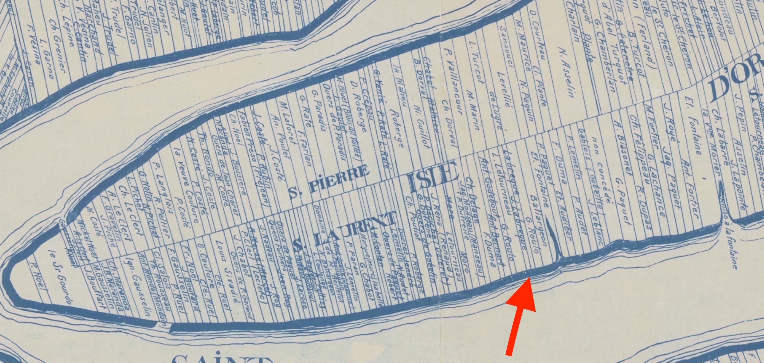
The lands allocated for clearing are very long, narrow, parallel bands stretching from the shore to the middle of the Island. Thus each family has direct access to the river.
The parish of Saint-Laurent is bounded on the north by Saint-Pierre; On the east by the river Maheu; To the south by the river; To the west by Sainte-Pétronille.
The first name of this place is Saint-Paul until 1696. Although in 1675, it took the name of Saint-Laurent, the first call is used.
Here is the detail of a map of the island of Orléans of Gédéon of Catalonia and drawn up by Jean-Baptiste Decouage.
(Click on the map to see the larger map)